Arctic Winter Sea Ice Ties Record Low, NASA, NSIDC Scientists Find
NASA and the National Snow and Ice Data Center (NSIDC) reported that Arctic winter sea‑ice extent reached a peak of 5.52 million square miles (14.29 million km²) on 15 March 2026, matching the lowest winter maximum recorded since satellite monitoring began in 1979. The measurement ties the 2025 peak of 5.53 million square miles, confirming a two‑year statistical tie for the smallest winter extent. The assessment was produced by scientists at NASA’s Goddard Space Flight Center and the NSIDC at the University of Colorado, Boulder.
The 2026 extent sits roughly 0.5 million square miles (1.3 million km²) below the 1981‑2010 average, reflecting a continued decline in Arctic ice cover. ICESat‑2 laser altimetry indicated thinner ice across the Barents Sea northeast of Greenland and reduced concentrations in the Sea of Okhotsk, a region noted for high interannual variability. Sea‑ice extent is defined by a minimum of 15 % ice concentration and expands during the Arctic winter before melting in the summer months. Historical observations have relied on the Defense Meteorological Satellite Program, while recent real‑time data are supplied by JAXA’s Advanced Microwave Scanning Radiometer 2 (AMSR‑2). Earlier records from the Nimbus‑7 mission (1978‑1985), jointly operated by NASA and NOAA, provide a baseline for long‑term trend analysis.
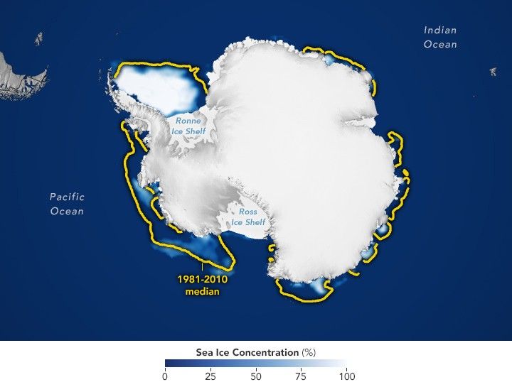
The findings reinforce a multi‑decadal downward trajectory in Arctic sea‑ice volume and multi‑year ice accumulation, a pattern highlighted by NSIDC scientist Walt Meier as significant when viewed in the context of the 1979‑present record. Although a single low‑ice year does not alone dictate climate outcomes, the repeated low maxima underscore the importance of continued satellite monitoring for cryospheric science. In the Southern Hemisphere, Antarctic summer sea‑ice minimum reached 996 000 square miles (2.58 million km²) on 26 February 2026—still 100 000 square miles below the 1981‑2010 average but well above the 2023 record low of 691 000 square miles—illustrating contrasting regional responses within the global sea‑ice system.