Satellite Spots a Spawn
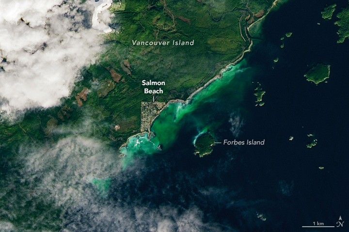
NASA’s Earth Observatory reported that the Operational Land Imager on Landsat 9 captured a clear view of a Pacific herring (Clupea pallasii) spawning event along the coast of Vancouver Island, British Columbia, on 19 February 2026. The satellite image shows a distinct green‑turquoise discoloration of the near‑shore water near Forbes Island in Barkley Sound, a location that has hosted herring spawns regularly since the 1970s. Observers on the ground recorded the arrival of herring schools on 13 February and documented spawning activity through 21 February, confirming that the visual signature in the Landsat data corresponded to an early‑season reproductive surge.
The Landsat 9 platform, launched in 2021, employs its OLI sensor to acquire multispectral data at 30‑meter resolution, enabling detection of the milt‑laden cloud that forms when male herring release sperm into the water. Female herring attach their adhesive eggs to kelp, seagrass, and rocky substrates, creating the optical contrast that the satellite records. Fisheries and Oceans Canada (DFO) and the Island Marine Aquatic Working Group (IMAWG) have long noted that herring prefer protected, low‑salinity sites with rocky bottoms, conditions that Barkley Sound provides. Researchers at the University of Victoria have incorporated decades of Landsat observations into a spatiotemporal analysis that refines historical spawn records and streamlines future detection algorithms. The spawning season, spanning mid‑February to early May, involves thousands of silvery fish that later migrate to deeper, nutrient‑rich feeding grounds, sustaining both commercial fisheries and First Nations cultural harvests.
Satellite monitoring of herring spawns expands the geographic and temporal coverage beyond traditional aerial surveys and diver observations, offering a consistent data source for ecosystem assessments. By mapping the distribution of this key forage species, remote‑sensing data can inform management decisions for salmon, sea lions, whales, and other marine predators that depend on herring. The integration of Landsat imagery with local knowledge and scientific analysis underscores the growing role of Earth‑observation assets in supporting sustainable fisheries and tracking marine‑environment changes along the Pacific coast.