March of the Harmattan
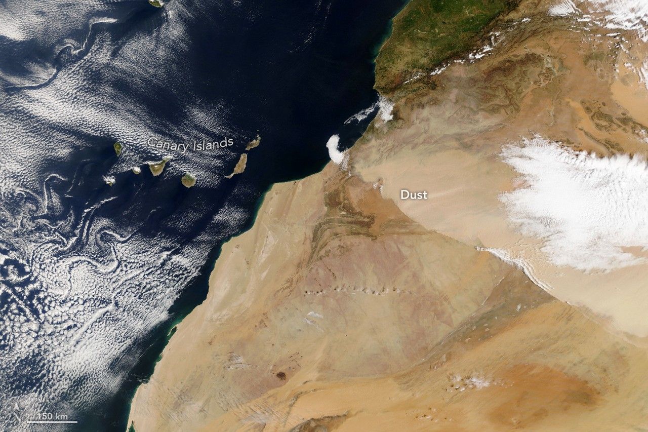
Strong winds associated with the Harmattan surge on 30 March 2026 lifted a dense Saharan dust plume that traversed north‑western Africa, crossed southern Morocco and moved southwest toward the Atlantic Ocean, prompting an orange‑level alert for reduced visibility and harsh conditions in several Moroccan regions. NASA’s Earth Observatory documented the event with a pair of satellite images captured in the morning and afternoon, while Spain’s state meteorological agency (AEMET) warned that the dust was expected to reach the Canary Islands, where it would produce the regional “calima” phenomenon through 1 April. The dust front, described as a light‑brown plume with a defined leading edge, reduced air‑quality levels and visibility across the affected territories.
The morning image was acquired by the Moderate Resolution Imaging Spectroradiometer (MODIS) aboard NASA’s Terra satellite at roughly 10:00 Universal Time (11:00 a.m. local time in Morocco). Four hours later, the Visible Infrared Imaging Radiometer Suite (VIIRS) on NOAA‑21 recorded the same plume as it shifted further southwest. A complementary view from Meteosat‑12, the geostationary weather satellite operated by the European Organisation for the Exploitation of Meteorological Satellites (EUMETSAT), tracked the dust’s progression toward the Canary Islands. AEMET noted that Harmattan winds, which blow from the northeast between November and April, intensified near the ground with the passage of a cold front, causing convergence perpendicular to the High Atlas range before redirecting the dust mass. The satellite data were processed through NASA’s EOSDIS LANCE, GIBS/Worldview and the Joint Polar Satellite System (JPSS) to produce the publicly released imagery.
The episode follows an earlier March dust storm that sent material toward the Canaries and another plume that spread across Europe, underscoring the seasonal peak of Saharan dust activity in spring when particles are lofted from central North‑African ergs and Mediterranean coastal zones. Researchers have repeatedly used NASA’s MODIS and VIIRS observations to quantify dust emissions, assess impacts on regional air quality and improve climate‑model representations of aerosol transport. Continuous monitoring by polar‑orbiting and geostationary platforms remains essential for early‑warning systems, aviation safety and the evaluation of trans‑Atlantic dust fluxes that influence weather patterns and ocean biogeochemistry.